


(TheNewswire)
 | |||||||||
Vancouver, B.C. – TheNewswire - November 17th, 2022 - Opawica Explorations Inc. (TSXV:OPW) (FSE:A2PEAD) (OTC:OPWEF) (the “Company” or “Opawica”) is pleased to announce it has received the 2D Seismic data from the Arrowhead Property in the Rouyn Noranda camp of the Abitibi in Quebec.
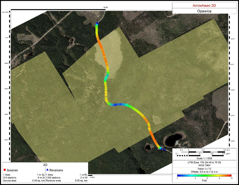
A two dimensional (2D) seismic survey is an exploration method used to create a map of the structures beneath Earth’s surface by sending energy waves into the Earth. Different rock formations reflect the waves back to the surface where they are recorded over a period of time and then converted into a seismic image. The objective of the 2D seismic survey is to define bedding domains to assist in selecting target definition drill holes to test various geologic domains under the cover rock. The depth of cover at Arrowhead is estimated at ~100m and it is important to image stratigraphy to a depth of ~500 to 700m. See Figure 1 for the location of the survey,
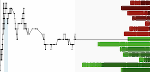
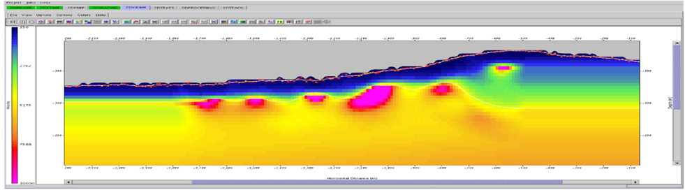
Figure 2 shows an identified anticline feature in the middle of the seismic line as indicated on the land streamer section. Figure 3 displays the results of the tomographic inversion of the first breaks (refraction technique) using the fixed receiver shot records. The correspondence with the anticline in the middle of the line and a number of high velocity areas may be indicative of mineralization which would have higher velocities than the host rocks. These anomalies do correspond somewhat with the anomalies highlighted on the land streamer data in Figure 2.
The downhole sonic logs were helpful in understanding the depths of the seismic reflectors observed. The sonic logs indicate rock velocities are in the range of 5,200-6,200m/s, which correlates to seismic reflectors are ~1km deep.
Blake Morgan, Chief Executive Officer of Opawica stated, “The 2D Seismic survey has been extremely useful on the Arrowhead Property in identifying buried targets. 2D Seismic is a cost-effective use of active seismic reflection profiling in mineral exploration. We now know what to do next and that is drill deeper. Our modelling has shown a direct resemblance to Agnico Eagles La Rhonde mine right next door. The large-scale gold mine is now down to around 3kms in depth. Shafts were initially started around the 500m level and that is what we are now seeing on Opawica Arrowhead project with the seismic data. The Opawica team will now define high priority drill targets and move towards a phase two drill program that will test the system at depth.”
The 2D Survey was a high-resolution reflection 2D line with 271 wireless receivers spaced at 12m and a single 15,000lb Envirovibe energy source to obtain high frequency data. Survey positioning was obtained real-time within the Vibrosies unit using very high-resolution GPS positioning (15cm lateral and 50cm vertical). The fixed receiver spread consisted of 271 X 3-component channels with max offset of 1,524m to ensure capture of the steeply dipping faults to be imaged even at shallow (less than 500m) depths. With this approach image faults and steeply dipping events from depth right to surface. The high-resolution shallow seismic spacing of 12m (20ft) and Energy source at 6m (20ft) enables 40-fold data capable of resolving layers and faults down to as little as 8m (25ft.) in thickness. Frequencies obtained with an accelerated weight drop are typically 60-70 Hz peak frequency and these frequencies cannot be tuned. By using an Envirovibe it was possible to “tune” the sweeps for these machines to increase high frequency content, sometimes as high as 180 HZ in shallow geologic sections which enables the vertical resolution of thinner layers as per the diagram below.
Figure 1 Location of 2D Seismic in the Arrowhead Property
Click Image To View Full Size
Figure 2 Anticline feature in the middle of the seismic line

Click Image To View Full Size
Figure 3 Tomographic Inversion
Click Image To View Full Size
Echo Geotech provides subsurface profiles acquired using their no surface Land Streamer equipment, and processes and interpreted using state-of-the-art seismic technology with reveals much more about the complexity of the subsurface. Echo Geotech will process and interpret data, thus providing Opawica with images and data that are decision ready. The multi-component land streamer system design allows Echo Geotechnical to simultaneously employ multiple techniques to extract subsurface physical properties.
Derrick Strickland, P. Geo (OGQ No. 35402), is the qualified person for Opawica Explorations, and has reviewed and approved the technical content of this news release.
About Opawica Explorations Inc.
Opawica Explorations Inc. is a junior Canadian exploration company with a strong portfolio of precious and base metal properties within the Rouyn-Noranda region of the Abitibi Gold Belt in Québec and in Central Newfoundland and Labrador. The Company’s management has a great track record in discovering and developing successful exploration projects. The Company’s objective is to increase shareholder value through the development of exploration properties using cost effective exploration practices, acquiring further exploration properties, and seeking partnerships by either joint venture or sale with industry leaders.
FOR FURTHER INFORMATION CONTACT:
Blake Morgan
President and Chief Executive Officer
Opawica Explorations Inc.
Telephone: 604-681-3170
Fax: 604-681-3552
Neither the TSX Venture Exchange nor its Regulation Service Provider (as the term is defined in the policies of the TSX Venture Exchange) accepts responsibility for the adequacy of accuracy of this news release.
Forward-Looking Statements
This news release contains certain forward-looking statements, which relate to future events or future performance and reflect management’s current expectations and assumptions. Such forward-looking statements reflect management’s current beliefs and are based on assumptions made by and information currently available to the Company. Readers are cautioned that these forward-looking statements are neither promises nor guarantees, and are subject to risks and uncertainties that may cause future results to differ materially from those expected including, but not limited to, market conditions, availability of financing, actual results of the Company’s exploration and other activities, environmental risks, future metal prices, operating risks, accidents, labor issues, delays in obtaining governmental approvals and permits, and other risks in the mining industry. All the forward-looking statements made in this news release are qualified by these cautionary statements and those in our continuous disclosure filings available on SEDAR at www.sedar.com. These forward-looking statements are made as of the date hereof and the Company does not assume any obligation to update or revise them to reflect new events or circumstances save as required by applicable law.
Copyright (c) 2022 TheNewswire - All rights reserved.

